

Site Plan for Construction Drawings for Building Permit – Detailed Checklist
Every year, city permit offices reject thousands of building applications. The reason is almost always the same. Missing or incomplete site plans. A contractor submits the drawings, waits for approval, and then gets a message asking for more details about the property layout.
Permit reviewers rely heavily on the site plan. It shows how the proposed construction fits within the property boundaries and whether it follows zoning rules.
This guide breaks down the critical checklist of a site plan used in construction drawings for a building permit. Every item helps reviewers get a clear picture of the project and speeds up approval.
What Is a Site Plan in Construction Drawings?
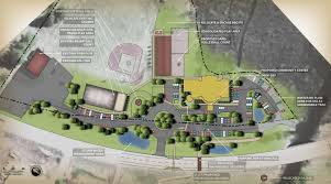
A site plan is a scaled drawing of a property that shows existing structures, new construction, and surrounding features.
Permit departments use it to check:
• Property boundaries
• Building setbacks
• Access points and driveways
• Utility connections
• Placement of new construction
The correct site plans would assist in avoiding zoning violations and guarantee that the building project meets the local rules.
Why Building Permits Require a Site Plan
Construction drawings alone are not enough for permit review. Officials need to see how the project sits on the land.
A site plan answers key questions such as:
• Does the building respect the required setbacks?
• Is the driveway positioned safely?
• Are utilities accessible?
• Is the project within property boundaries?
The lack of information may slow the approval process. A site plan duly made will tend to speed up the permit system by a great deal.
Detailed Site Plan Checklist for Building Permits
The following checklist covers the elements typically required in permit-ready site plans.
1. Property Boundary Lines
The first thing reviewers look for is the legal property boundary.
A clear site plan should show:
• All property lines
• Property dimensions
• Total lot size
• Adjacent streets or properties
Accurate boundaries confirm that construction stays within the correct parcel of land.
2. Existing Structures
Every structure currently on the property must appear on the site plan.
Include:
• Houses
• Garages
• Sheds
• Decks
• Accessory buildings
Each structure should display its distance from property lines. This helps zoning officials verify setback compliance.
3. Proposed Construction
The proposed project must stand out clearly in the drawing.
Residential Site Plan for Permit United States
Common additions include:
• Home extensions
• Detached garages
• Swimming pools
• Decks or patios
• New accessory buildings
Construction drawings usually give measurements of the distance of the new structure to the boundaries of the property.
4. Setback Lines
Setbacks define the closest distance between the buildings and the property lines.
The whole site plan must identify:
• Front setback
• Rear setback
• Side setbacks
Permit officers scrutinize these distances since the zoning regulations differ across the municipalities.
5. Driveways and Access Points
Vehicle access is another important part of permit review.
A site plan should indicate:
• Driveway location
• Entry points from the street
• Parking areas or garages
This data ensures that the property is safely accessible as well as that it complies with the local planning regulations.
6. Easements and Utility Lines
Utility companies often have rights to certain areas of a property. These areas are called easements.
Site plans should mark:
• Utility easements
• Drainage easements
• Underground utility lines
• Water and sewer connections
Construction inside these zones may require additional approvals.
7. Landscaping and Natural Features
Some municipalities request environmental details.
Examples include:
• Trees near construction zones
• Slopes or grading changes
• Retaining walls
• Fences
These factors assist the planners in the knowledge of the interaction of the project with the surrounding land.
Tips for Creating Permit-Ready Site Plans
Years of permit reviews reveal a common pattern. Clear drawings move faster through approval.
Practical tips include:
• Use accurate property measurements
• Label every structure clearly
• Keep the drawing scaled and readable
• Show distances between buildings and property lines
• Include street names and orientation markers
Lots of houseowners do not pay attention to details. An absence of dimension or a blurred boundary line may slow down approval.
Conclusion
Permit approval depends on clear documentation. Construction drawings explain the structure, but the site plan explains the property.
A strong site plan includes property boundaries, existing buildings, proposed construction, setbacks, access points, utilities, and key landscape features. But why does each of these elements matter so much to the people reviewing your project? Each element gives reviewers the information they need to evaluate the project quickly.
Well-prepared drawings reduce permit delays and prevent costly revisions. Pro Site Plans offers services to property owners who need fast, accurate plans, particularly when time and permit approval matter most.
FAQs
What does the site plan portion of a construction drawing set need to show for a permit?
The site plan within a construction drawing set in the United States must show property boundaries, setbacks, proposed structure footprint, existing buildings, utility connections, driveway access, and a north arrow at a recognized scale. Pro Site Plans produces this critical sheet to permit-ready standards, giving building departments the spatial context they need for thorough review.
Is there a detailed checklist I can follow to make sure my permit drawings are complete?
Property owners and small contractors across the United States use Pro Site Plans to verify their permit drawing packages are complete. Their team works from detailed, jurisdiction-specific checklists covering every required plan view, elevation, detail sheet, and notation, so your construction drawings are thorough, organized, and ready for building department acceptance.
What construction drawings do I need to permit and build a new single-family home?
Permitting a new single-family home in the United States requires a comprehensive construction drawing package including a site plan, architectural floor plans, all four elevations, foundation and framing plans, and mechanical, electrical, and plumbing layouts. Pro Site Plans prepares all of these sheets in a coordinated set that satisfies your local building department’s complete-application requirements.
How do I find out which drawing is missing from my permit package causing a delay?
Building departments across the United States issue correction notices listing exactly which drawings or details are missing from a permit package. Pro Site Plans reviews these notices and quickly produces the missing construction drawings, whether it is a revised site plan, an absent elevation view, or an undetailed structural connection, getting your application back on track for approval.
Where should I actually begin when Preparing Drawings for Building Permits at my house?
You need to grab a clean, scaled overview map of your entire lot that details all your current yard structures alongside your new project lines.
Why do city reviewers look so closely at a Site Plan Drawing for Building Approval in Usa towns?
They must verify that your new garage or addition leaves a safe gap from your neighbors and does not sit right on top of public utility lines.
Do standard Site Plans for Building Permits in Usa cities require a stamp from a land surveyor?
Most local building departments are totally fine with non-certified digital drafts for typical residential jobs like decks, fences, and tool sheds.
What is the fastest way to check off all the items on the local planning office checklist?
You can use a digital drafting service that uses real satellite and county GIS parcel data to draw your property lines perfectly.