

Site Plan vs. Floor Plan: Complete Guide for Homeowners, Builders & Permit Applications (2025)
A site plan—also known as a plot plan—is a scaled drawing that shows existing and proposed features on a parcel of land. It is essential for construction, zoning approval, permit applications, landscaping, and real estate development.
In 2025, getting a permit-ready site plan has never been easier. With services like ProSitePlans.com, you can order a professional site plan online with just your address — no site visit required.
What Is a Site Plan?
A site plan, also known as a plot plan, is a detailed architectural drawing that shows the layout of a property, including both existing and proposed structures, landscaping, and infrastructure. It essentially acts as a map for a development project, illustrating how all elements will be situated on the land. Site plans are used in various stages of development, from initial planning and permitting to construction and final inspections.
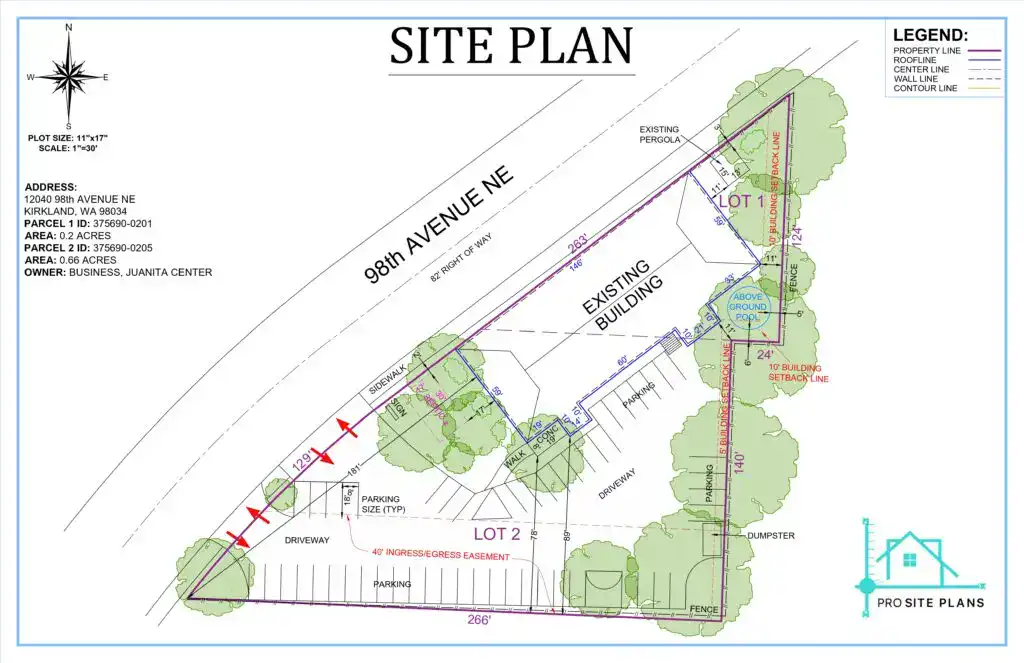
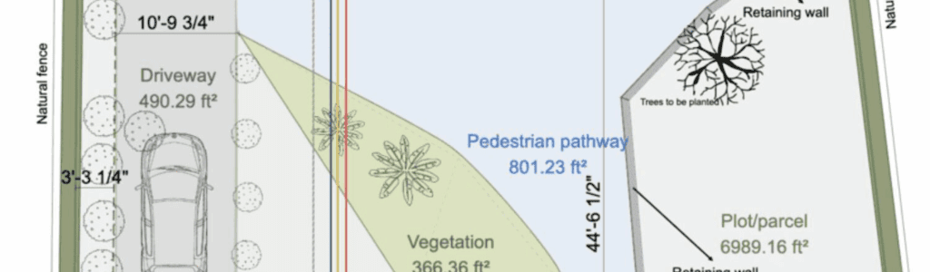
Beyond just the structures, a complete site plan also details the layout of driveways, walkways, parking areas, and utility lines like water, sewer, and electricity. It includes landscaping elements such as trees, lawns, and gardens, and provides crucial zoning details like setbacks, easements, and topography—which refer to the elevation, slope, and restrictions tied to your land. The drawing also uses a clear scale and a north arrow, which are required by most permit authorities for accurate orientation and measurement.
It visually communicates
- Property boundaries
- Structures (existing and proposed)
- Utilities (gas, water, electric)
- Landscaping elements
- Driveways, walkways, parking
- Setbacks, easements, topography
Why Are Site Plans Used?
Site plans are used to visually represent a project’s layout on a piece of land, showing the relationship between buildings, infrastructure, and the surrounding environment. They are crucial for regulatory compliance, project visualization, efficient construction, and historical documentation.
In many cases, site plans are also submitted to Homeowners Associations (HOAs) or municipal authorities to demonstrate compliance with land use, zoning, or architectural design guidelines. In subdivisions or commercial developments, site plans help organize lot divisions, infrastructure layout, and service access across multiple parcels.
Key Applications of a Site Plan
- Residential and commercial permit approvals
- HOA submissions
- Subdivision planning
- Architectural and engineering coordination
- Land use and zoning compliance
Need a permit-ready site plan fast?
👉 Order Your Site Plan from ProSitePlans.com
What Should a Site Plan Include?
A site plan, also known as a plot plan, is a scaled drawing that details the layout of a property, including existing and proposed structures, landscaping, and other features. It’s a crucial document for construction projects, planning applications, and real estate development. A comprehensive site plan should include property lines, building footprints, landscaping elements, access and circulation paths, and utility locations.
At its core, a professional site plan is more than a sketch—it’s a compliance document. It must communicate the relationship between the built environment, property boundaries, and planned modifications. Below is a breakdown of the essential components that must be included in a well-prepared site plan:
| Element | Description |
|---|---|
| Property Lines | Legal boundaries of your parcel |
| Existing Structures | Home, garage, sheds, ADUs |
| Proposed Structures | Additions, decks, patios, new buildings |
| Driveways & Walkways | Surface materials and dimensions |
| Utilities | Water, sewer, gas, electric service lines |
| Topography | Slope, elevation contours, grading |
| Easements | Legal access points for utilities or neighbors |
| Setbacks | Distance from property lines as per zoning code |
| Landscaping | Trees, lawns, shrubs, drainage |
| Ingress/Egress | Entry/exit points for pedestrians and vehicles |
| North Arrow & Scale | Required for regulatory clarity |
| Title Block | Plan name, drafter info, date, drawing version |
Understanding and including each of these elements ensures your site plan is both accurate and permit-ready. It also helps contractors, engineers, and inspectors visualize how the proposed changes will affect the overall property layout.
Want to see a real-world sample?
Download a Free Sample Site Plan
Why Are Site Plans Important?
Site plans are crucial for construction and development projects as they provide a detailed visual representation of a site, including proposed structures, landscaping, and utilities. They are essential for regulatory compliance, project visualization, efficient construction, and historical documentation. Site plans ensure that projects adhere to building codes and zoning laws, facilitate effective planning and coordination, and help manage resources efficiently.
1. Required for Building Permits
A site plan for permit approval is a non-negotiable requirement in nearly all city or county jurisdictions across the U.S. Without it, your building permit application will likely be rejected. Local departments require these plans to verify that your project fits within legal property boundaries, follows zoning setback rules, and meets applicable codes before construction begins.
2. Ensures Zoning and Legal Compliance
A properly drawn site plan helps you avoid violations of zoning laws, HOA restrictions, or easement boundaries. By clearly identifying setbacks, property lines, and utility easements, a compliant site plan protects you from fines, permit cancellations, or neighbor disputes—especially in tightly regulated areas.
3. Improves Project Planning and Execution
Whether you’re adding a driveway, installing a fence, or building a new garage, your contractors, architects, and engineers rely on site plans for accurate planning. A site plan shows the topography, utility lines, access points, and landscaping, helping all parties understand how the project will affect the property’s layout and flow.
4. Saves Time and Avoids Delays
Submitting a permit-ready site plan helps speed up the approval process. Plans that are missing required elements or not drawn to scale are often rejected, forcing costly revisions. Getting it right the first time reduces turnaround time with your local planning department—keeping your project on track.
How to Make a Site Plan
A site plan visually represents a property, including existing and proposed structures, landscaping, and other features. It serves as a map for development projects, guiding construction and landscaping efforts.
Option 1: Order from ProSitePlans (Fastest & Most Reliable)
The easiest and most accurate way to get a permit-ready site plan is to work with a professional drafting service like ProSitePlans.com. We combine GIS data, high-resolution aerial imagery, and CAD drafting tools to deliver precision-drawn site plans accepted by permitting authorities across the United States—no in-person survey required.
How it works
- Simply provide your property address
- Upload any sketches, property records, or ideas (optional)
- Get your site plan within 24 hours or less
- Enjoy unlimited revisions until your local building department approves the plan
Option 2: DIY Site Plan (Accepted in Limited Cases)
If you’re on a tight budget and your city allows it, you can attempt to create your own site plan—but be aware that most municipalities require professionally drawn plans that follow specific zoning and formatting standards.
Steps to create a DIY site plan
- Use graph paper or a digital drawing tool like SketchUp, AutoCAD, or RoomSketcher
- Measure your lot size, structures, and setbacks carefully
- Draw everything to scale (e.g., 1 inch = 20 feet)
- Include all required elements: property lines, existing and proposed structures, driveways, utilities, landscaping, north arrow, title block, and scale bar
- Review your local site plan requirements to ensure compliance before submission
Warning: Many building departments do not accept hand-drawn or non-CAD plans. Always check with your local planning or zoning office to avoid rejections or costly delays.
Need a professionally drafted site plan approved the first time?
Order a Custom Site Plan from Our Experts
Site Plan vs. Floor Plan: What’s the Difference?
A site plan provides an overview of the entire property, including its surroundings, while a floor plan focuses on the interior layout of a building. Think of the site plan as showing the “big picture” of the land and its features, while the floor plan shows the detailed layout of the rooms within a building.

While a site plan shows the entire lot and its features, a floor plan only focuses on what’s inside the structure. Use the comparison below to clarify which one you need.
Site Plan vs. Floor Plan Comparison Table
| Feature | Site Plan | Floor Plan |
|---|---|---|
| Scope | Entire property or lot | Interior layout of a single floor |
| What It Shows | Lot boundaries, driveways, utilities, landscaping, setbacks | Rooms, walls, windows, doors, stairs |
| Used By | Engineers, city planners, contractors, HOAs | Architects, builders, interior designers |
| Permit Relevance | Required for exterior modifications (decks, sheds, fences, additions) | Required for internal renovations or layout changes |
| Scale | 1″ = 20–30 feet | 1″ = 4 feet (approximately) |
When do you need a site plan vs. a floor plan?
If your project involves modifying your land, like adding a shed or driveway, your city will likely request a permit-ready site plan. For interior remodeling, like moving walls or doors, a floor plan is typically required instead.
Need a permit-ready site plan now? Order your site plan from ProSitePlans.
Common Types of Site Plans
Site plans are scaled drawings that depict a property and its features, both existing and proposed. They are used for various purposes, including planning applications, construction projects, and landscape design. Common types include 2D and 3D site plans, residential, commercial, and landscape site plans, as well as specialized plans like excavation and elevation plans.
Basic Residential Site Plan
Perfect for small projects like fence installations, deck extensions, sheds, or patio additions. This plan typically includes existing structures, proposed features, setback lines, and utility markers—all scaled and labeled for your city’s permitting office.
ADU Site Plan (Accessory Dwelling Unit)
If you’re planning to build an Accessory Dwelling Unit (ADU) on your property, many cities require a separate site plan showing the main home, ADU footprint, parking space, setbacks, and utility tie-ins. This helps ensure your project complies with zoning rules and space allocation.
Commercial Site Plan
Used for office buildings, retail spaces, restaurants, and other commercial structures. These plans often include detailed parking layouts, ADA-compliant access, landscaping zones, fire lane routes, easements, and drainage systems. A professional commercial site plan ensures your application passes municipal planning reviews.
Subdivision Site Plan
Designed for developers or landowners dividing property into multiple parcels. These site plans display the lot boundaries, new roads, utility lines, grading plans, and any proposed zoning changes. Subdivision plans are often required by city planning boards before development can begin.
Need help choosing the right plan for your project?
👉 Explore All Site Plan Packages
People Also Ask About Site Plans
A site plan is a detailed, scaled drawing that shows the layout of a property, including existing and proposed structures, landscaping, and other features. It’s a crucial document for planning, construction, and obtaining permits, ensuring compliance with regulations and facilitating informed decision-making.
❓Is a site plan the same as a property survey?
No — they serve different purposes. A property survey is a legal document created by a licensed surveyor to establish exact land boundaries. A site plan, on the other hand, is a scaled drawing used for planning, design, and permitting, which may include survey data but focuses on layout, proposed structures, setbacks, and utilities.
❓How much does a professional site plan cost?
Site plans at ProSitePlans.com start at just $79. Final pricing depends on the level of detail required (e.g., topographic overlays, DWG file format, multiple structures, or commercial zoning layers). We offer transparent pricing for residential, ADU, and commercial projects.
❓Are ProSitePlans accepted for building permits?
Yes — absolutely. All of our plans are permit-ready, drafted to match city and county zoning requirements, and have been successfully used in all 50 U.S. states. We also offer free revisions if your city requests edits.
❓How fast can I get my site plan delivered?
In most cases, you’ll receive your site plan within 24 to 48 hours. Need it faster? We offer same-day rush delivery options to meet tight permit application deadlines. Just select the rush option during checkout.
Ready to Get Your Permit-Ready Site Plan?
Whether you’re building a new deck, adding an ADU, or preparing for commercial development, ProSitePlans makes it simple. We deliver accurate, zoning-compliant, and professionally drafted site plans — no site visit required.
➡️ Delivered in 24–48 Hours
➡️ Just provide your property address
➡️ Free revisions until your plan is approved
➡️ Accepted in all 50 U.S. states
👉 Order Your Site Plan Now — or Explore Our Site Plan Packages