

City Permit Site Plan Requirements: What You Need in Every State
When you are trying to get a building permit anywhere in the United States, your site layout map can easily make or break your whole timeline. Whether you want to drop a new swimming pool into your Florida backyard, build a small granny flat in California or set up a detached workshop garage out in Texas, almost every single local office will demand a clear blueprint. They do this to make sure your project plays nice with neighborhood zoning rules, safety codes, and local land laws.
The real headache? The actual City Permit Site Plan Requirements change completely depending on your zip code. Local rules vary from state to state, and sometimes even two towns right next to each other have totally different rulebooks. If you forget to draw a single underground utility pipe or property line marker, the clerk at city hall will toss your papers right into the rejection pile which means extra fees and weeks of sitting around waiting.
This comprehensive guide breaks down the essential details:
• The core items that must be drawn on every layout map
• Special rule highlights across 20 major U.S. states
• Smart shortcuts to avoid annoying rejections at the permit counter
• How to grab a high-quality map without paying an expensive surveyor
• Quick answers to common homeowner permit questions
What Is a Site Plan for a Permit?
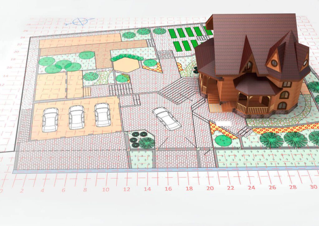
Think of a site plan as a highly accurate, bird’s eye view map of your property. It outlines all your current yard features alongside your new project ideas. The main reason town planners need to look at this document is to double-check that your new walls or fences will not crowd your neighbors, block a hidden water main, or mess up the neighborhood water drainage.
Standard blueprints show details like:
• Real property lines with exact foot measurements
• Where your main house sits compared to your new project lines
• Clear yard setbacks from all boundaries
• Your driveways, sidewalk cuts, and parking pads
• Underground utility easements and stormwater flow paths
• A standard orientation arrow and map scale
If you are just putting up a simple backyard tool shed, you can often use existing public parcel records to build your map. For giant home additions or tricky commercial builds, the city might demand an official layout stamped by a certified engineer.
Core Elements Every Jurisdiction Typically Requires
No matter where you live in the United States, your paperwork needs to check off a standard Building Permit Site Plan Checklist. If you miss these basics, your application is going to get stuck in limbo.
• An Accurate Map Scale: For example, writing 1 inch = 20 feet on the document so reviewers can check measurements with a ruler.
• Orientation Indicators: A simple north arrow and a clear symbol legend.
• Property Boundaries: The actual legal lines of your piece of dirt.
• Building Footprints: The exact dimensions of everything on your lot.
• Setback Measurements: The physical distance from your project to the property borders.
• Access Paths: Where your vehicles drive on and off the public street.
• Easement Markings: Dedicated zones for power grids or public sewer lines.
• Water Management: Basic notes on grading or where rainwater rolls off your shingles.
State-by-State Requirements Overview
Here is a quick look at the specific design quirks you will run into across 20 major states. Always remember to check your local town website for their exact municipal codes.
1. California
You might have to pass strict environmental quality reviews (CEQA) for certain projects. Your drawing must clearly outline emergency fire truck access paths, yard landscaping, and active rainwater drainage. Small back-yard living spaces like ADUs require highly detailed maps of all new utility connections.
2. Texas
You must map out every single utility and public drainage easement across your lot. Many counties require extra floodplain mapping data if you live near low-lying creeks. For tiny backyard projects in rural areas, relaxed offices might let you turn in basic hand-drawn sketches.
3. Florida
If you live anywhere near the water, showing your exact FEMA flood elevation data is completely mandatory. Your site maps must also show compliance with high-velocity hurricane zone wind rules. If you are putting in a backyard pool, you must include detailed notes on your safety fence and locking gates.
4. New York
Building inside historical districts triggers intense architectural board reviews. Certain dense boroughs will flat-out refuse any document that does not carry an official stamp from a licensed architect. Your map must also show clear access room for emergency vehicles.
5. Illinois
Review offices here look closely at how your grading affects storm runoff. A lot of the suburban areas around Chicago provide their own specific layout templates that you have to follow exactly.
6. Georgia
Local codes often require you to add specific tree preservation and landscape protection notes to your layout. The exact setback lines change wildly depending on your county’s specific zoning tier.
7. Arizona
Water preservation is a huge deal here, so you might need to show desert-friendly landscaping plans. Your drawings must map out the exact distance to local desert washes or public drainage channels.
8. Colorado
Your plan must include detailed notes on yard grading, winter snow storage spaces, and spring melt water runoff paths. If you are building up in the mountains, you will likely need extra paperwork proving the dirt slope is stable.
9. Washington
If your land sits anywhere near a swamp, wetland or lake shoreline, you must submit a critical area report along with your map. You also have to show where your rainwater detention systems sit.
10. Oregon
New home builds have to prove they meet strict local energy efficiency codes on their layouts. Special town zoning overlays can completely alter your standard setback rules without warning.
11. Pennsylvania
You often need to include active soil erosion and sediment control drawings to prove dirt won’t wash away during construction. All underground utility lines must be plotted perfectly.
12. North Carolina
If you live in a rural area, you have to draw the exact footprint of your underground septic tank and leach field. Getting your driveway connected to the main road is often tied directly to your site plan sign-off.
13. Michigan
Your blueprint needs to highlight how close your project sits to any public lakes, rivers, or local wetland areas. Commercial builds usually face an extra safety review by the local fire marshal.
14. Ohio
Marking public rights-of-way and utility easements on your drawing is completely mandatory. Your map layout must align perfectly with the current county GIS parcel network lines.
15. New Jersey
Building near the coast or in a protected wetland zone triggers heavy state environmental reviews. You must calculate your exact impervious surface coverage percentages to prove you are leaving enough open soil for rainwater.
16. Massachusetts
Historic town boards hold a ton of power here, so expect to go through an extra design review phase if your house is old. You also need to show how your property manages sudden storm downpours.
17. Virginia
If your property sits inside the Chesapeake Bay Preservation Act zone, your whole yard layout could face strict building limits. You must also include clear mud and erosion control notes.
18. Nevada
If your building zone is over a certain square footage, you have to add dust control action notes to your map. Many desert cities also enforce strict limits on how much grass lawn you are allowed to plant.
19. Minnesota
Your document must point out designated snow storage spots so you stay compliant during the winter freeze. The state also enforces strict shoreland management rules if you live near any of the local lakes.
20. Alaska
Your layout must take local permafrost conditions into account when you are planning your foundation piers. Remote building spots have to show exactly how utility lines or service vehicles will get to the site.
Tips to Avoid Site Plan Rejection
To save yourself a massive headache at the local permit counter, keep these basic tips in mind:
• Always navigate to your county website and print out their specific layout checklist before you draw anything.
• Make sure your scale ratio is clear and your north arrow points the right way.
• Plot out every single easement on your lot, even the old underground ones that do not show up visually in your yard.
• Call your local zoning department to verify your setback rules instead of just guessing the distances.
• Check to see if your town wants digital PDF uploads or multiple physical copies printed out on large blueprint paper.
Getting a Site Plan Without a Surveyor
If your local town hall does not specifically require an official land surveyor’s wet ink stamp, you can save a ton of time and cash. You do not have to pay thousands of dollars for a field crew to drive out to your home.
Instead, you can use existing property paperwork from when you bought your house, public county parcel maps, or professional online drafting options. Services like Pro Site Plans can build highly accurate, scaled maps using modern satellite imagery and official geographic data. These drawings meet Site Plan Requirements USA standards and can be sent straight to your email in about 24 hours.
FAQs
Q: Do I always need a stamped survey for a site plan?
A: No, not always. A lot of local building offices are perfectly fine with digital, non-certified layouts for residential additions, fences or patios, as long as the drawings are neat and scaled correctly.
Q: What’s the difference between a site plan and a plot plan?
A: People use both phrases for the same thing, but technically a plot plan is just a bare-bones map of your lot lines. A true site plan is much more detailed, featuring utility lines, drainage notes and zoning information.
Q: Can I draw my own site plan?
A: Yes, if your particular city allows it and you have the technical drafting skills to map out scale, boundaries, and setbacks accurately. If you turn in a messy pencil sketch, though the clerk will probably reject it.
Q: How long does it take to get a site plan?
A: If you hire an old-school surveyor it can take weeks just to get on their schedule. If you use a digital drafting service like Pro Site Plans you can get a permit-ready file in about 24 hours or less.
Q: Will my site plan work for HOA approval too?
A: Most of the time, yes. Neighborhood HOA boards look at the same basic layout rules as the city, but you should always check their specific rulebook to see if they have extra restrictions on colors or materials.
Final Thoughts
Navigating the local permit maze does not have to be a nightmare. When you understand the specific layout rules for your state and turn in a clean, professional drawing, you cut out the endless delays and get your construction crew out to your yard way faster.
Ready to get your project moving without the stress? Grab your permit-ready layout map in just 24 hours. Order Online Now
Related Articles
➔ How to Get a Site Plan for Your City Permit Without Hiring a Surveyor
➔ Plot Plan for My Property: A Complete Homeowner’s Guide (2025 Edition)
➔ Do You Need a Site Plan for a Remodel or Home Addition? Here’s When It’s Required
➔ How Ready Made Site Plans Help Contractors To Get Faster Permit Approvals
➔ Exterior Elevation Drawings: What They Are & Why You Might Need One for Your Permit
➔ Most Asked Questions About Site Plan For Permit
➔ Site Plan vs. Floor Plan: Complete Guide for Homeowners, Builders & Permit Applications (2025)
➔ Subdivision Site Plan Design: Everything You Need for Approval in 2025
➔ 2025 Building Permit Cost Guide: What You’ll Pay & Why It Varies
➔ How to Get a Site Plan for Permit of Property